Geo-Grid Rank Tracking
See exactly where you rank on Google Maps from hundreds of coordinates around your business. Interactive heatmaps reveal your visibility street by street, postcode by postcode. So you know where you're winning and where competitors are eating your lunch.
Why it's different
Built for the way local SEO actually works
Up to 21×21 grids
441 scan points per location. Dial grid spacing from 50 m up to 100 km.
Works worldwide
Every country where Google Maps operates. London, Lagos, Sydney, San Francisco.
Scheduled scans
Run daily, weekly, or monthly. Spot ranking drops the day they happen, not a week later.
Client-ready reports
Shareable links with your branding. No logins needed for clients to view results.
Precision
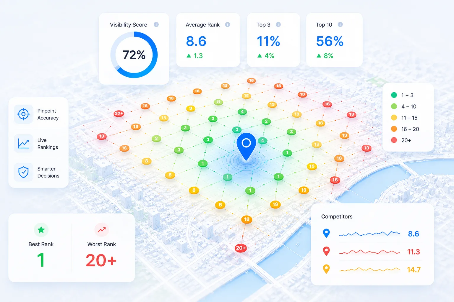
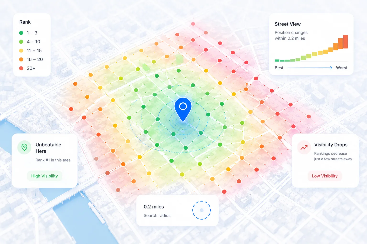
Rankings that change street by street
Traditional rank trackers check from a single location and give you one number. That number is a lie. Your business ranks differently on every block. Geo-grid tracking scans from hundreds of points around your location so you see exactly where you dominate and where you're invisible.
- Colour-coded pins (green = top 3, yellow = 4–10, orange = 11–15, red = 16–20, grey = unranked)
- Tap any pin to see exact rank and the local pack returned from that coordinate
- Compare scans side-by-side to track ranking shifts over days, weeks, or months
Coverage
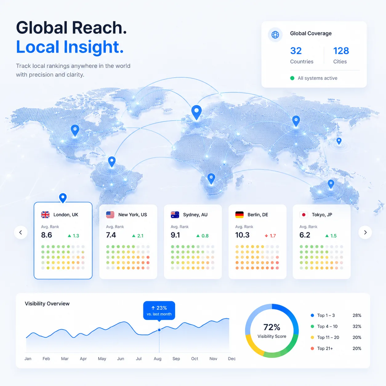
Global reach, local insight
SearchOps works in every country where Google Maps operates. Whether you're tracking a plumber in Shoreditch or a dental clinic in Sydney, the same geo-grid engine gives you the same precision. Pick your centre point, grid size, and spacing. We handle the rest.
- Any country, any language supported by Google Maps
- Grid spacing from 50 m (dense urban) up to 100 km (regional coverage)
- Up to 21×21 grids (441 scan points) on Pro and Agency plans
Competitive intelligence
See who outranks you, pin by pin
A rank number tells you where you stand. It doesn't tell you who is standing in front of you. Tap any grid pin and SearchOps shows the full local pack returned from that exact coordinate, so you can see which competitors own the blocks where you're invisible.
- The full local pack from every pin, not just your own position
- Spot the competitors who dominate specific neighbourhoods or postcodes
- Feed the strongest competitors straight into a GBP benchmark audit
How it works
Three steps from signup to insight
Add your location
Paste your business name and address. We geocode it automatically and set up tracking in seconds.
Configure the scan
Pick a keyword, grid size, and spacing. You see the exact credit cost before you run it.
Get your heatmap
Interactive heatmap with rank pins across every grid point. Share a branded link with clients in one click.
Credits
What does a scan cost?
Each grid point costs 1 credit. Small grids covering a single neighbourhood are cheap; wider grids covering a whole city cost more. Every plan includes a generous monthly allowance. See the pricing page for details.
- A 7×7 grid = 49 credits
- A 13×13 grid = 169 credits
- A 21×21 grid = 441 credits
FAQ